BELLOBEACH.COM
Presenting several galleries of photos from an old album of promotional photos compiled by Jim Weil and his sister, Lucia Harris, of the original Muir Beach Company, which sold the lots on the lower, Pacific and Sunset Way, portions of Muir Beach.
It is my understanding that they named the community Muir Beach, feeling that the association with the world famous Muir Woods would help locate and promote the new community. I have heard that the old lots, only about 35 by 100 feet, were even given away with subscriptions to the San Francisco Examiner, as a promotion. If anyone finds any written evidence for this I would enjoy adding it to the website.
Any additional information, anecdotes, nostalgia, photos, documents, recollections, will be gladly accepted for addition to this collection, and many have been already. The additional galleries listed below contain not only old maps and aerial shots, but snapshots from different families, resident or just visiting. You can contact George Kristian Lindholdt, 415-388-8455, asbjerg@aol.com, and you are welcome to visit my homepage, Lindholdt.com, also a work in constant progress.
SITE CONTENTS:
History of Muir Beach
UPDATE Memories of Muir Beach UPDATE
Gallery 1
Gallery 2
Gallery 3
Gallery 4
Photos from the late 1890's
Old Maps
Aerial Photos
Miscellaneous Photos
The Tale of the Tavern: 1, 2, 3, 4
The Souzas
Maps and Aerial photos courtesy of the National Park Service
in relation to the
Big Lagoon Wetland and Creek Restoration ProjectAnd here's a link to a Muir Beach webcam.
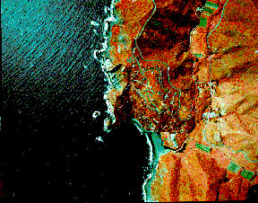
Here is a recent false-color photo of Muir Beach:
Last updated: 3/26/05